Trekking Sardinia: 10 routes not to be missed
Trekking Sardinia: how to travel while respecting the environment
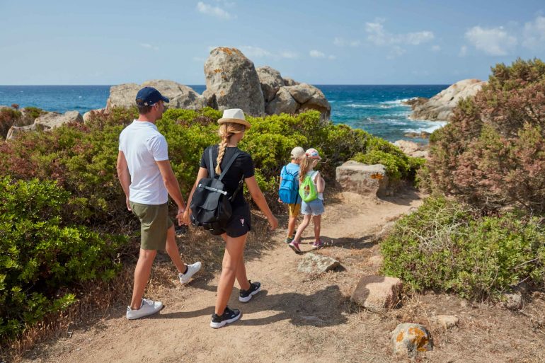
Trekking in Sardinia is the best way to get to know the island’s territory and discover the natural and archaeological wonders that form the inestimable historical, environmental and landscape heritage of ancient Ichnusa.
The word ‘Trekking’ comes from the English verb ‘to trek’ and means “to walk slowly” or “to make a long journey”. Trekking is a sports activity based on the idea of walking over a territory, along paths such as long-distance roads, high roads, mule tracks and horse tracks which cannot be crossed by conventional means of transport.
Those who trek can simply walk and enjoy the surrounding landscape or add other activities to their walk such as birdwatching, the observation of botanical species and visit natural monuments or archaeological sites along the way.
A good hiker must pay attention to a few simple and basic rules:
- Respect the surrounding environment
- Not damage the signs
- Not leave rubbish
- Not pick protected botanical species
- Not disturb wildlife
- light fire only in suitable places and make sure to turn it off properly before setting off again
Would you like to discover the ancient island of Ichnusa in all its authenticity? We will tell you about the 10 best Sardinian hiking routes
Trekking in Sardinia: the 10 most beautiful routes of the island
Let’s see which are the ten trekking routes in Sardinia to do at least once in a lifetime.
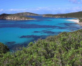
- Monte Arcuentu: 785 meters above sea level, Mount Arcuentu is in the Southern province of Sardinia, more precisely in the municipality of Arbus, and is part of a mountain range running parallelly for eight kilometres to the beaches of the beautiful Costa Verde. On the top of the mountain, not far from the mines of Montevecchio, you can admire the medieval castle ruins of Arcuentu or Erculentu which are described by Italian historian Francesco Cesare Casula in his Sardinian Historical Dictionary. The name of the mountain is composed of the Sardinian words árcu, which means “curved” or “arch-shaped” referring to the particular shape of the rocks at the summit, and ‘entu o bentu, ie “wind”. From the summit of Mount Arcuentu you can see the peninsula of Sinis, the Giara, Mount Arci, the Gulf of Oristano, the Gennargentu, the Sette Fratelli massif, Mount Linas and the Campidano plain. The vegetation is typical of the Mediterranean maquis and makes the tuffs and basalts of volcanic origin that characterize the landscape show up.
- Cascata di Piscina Irgas: the waterfall is in the municipality of Villacidro, in the province of South Sardinia on the border with Domusnovas territory and is surrounded by peaks up to 700 meters high. The Irgas Pool, together with Sa Spendula and Muru Mannu, is one of the most famous waterfalls of the island and can be reached after about two hours walking on the CAI path number 113. The path crosses Rio Cannisoni and is characterized by dense vegetation composed mainly of holm oaks, strawberry trees, heathers, junipers, cistus, cork oaks and oleanders. The granite rock mountains surrounding the waterfall are home to deer, wild boar and mouflon. From Punta Piscina Irgas you can see Punta Màgusu, also called Punta Cucuerris or Punta Cannisoni, with its 1000 m and in the distance, you can see Mount Linas in the distance, the highest mountain in the whole Campidano.
- Miniere del Blu: is a coastal route that crosses the wildest and most unspoilt area of the Costa Verde and from the beach of Scivu, it continues south to the municipalities of Nebida and Masua. From the beaches of Arbus, you can go to the village of Buggerru and then Masua, a coastal hamlet of Iglesiente, where there is the Porto Flavia mining site and the majestic Pan di Zucchero. The itinerary of the Miniere del Blu opened in 2012 and today it’s one of the most loved paths by trekkers because it allows you to admire from close up monuments of the industrial archaeology like Porto Flavia, ancient mining settlements, incredible geological formations and places of great natural interest including the dunes of Piscinas, the coast Buggerru, Capo Pecora, Cala Domestica and the coast of Nebida.
- Selvaggio blu: is one of the most famous, beautiful and challenging treks in Europe, included in the list of the 100 most spectacular trails in the world and also mentioned in the New York Times. An incredible path in the heart of Ogliastra and extends for over 40 kilometres from Santa Maria Navarrese to Cala Gonone, along the cliffs of Orosei and up to Cala Luna among challenging trails, limestone cliffs, caves, rivers, rock faces, beautiful bays with crystal clear water, fragrant woods of holm oaks and junipers, arches carved into the rock, mule tracks and shelters of shepherds. The Selvaggio Blu was conceived in 1987 by Mario Verin, photographer and mountaineer, and Peppino Cicalò, architect and president of the Nuoro section of the Italian Alpine Club. It takes four to seven days to complete this difficult journey, far from civilization, without signs, refuges or roads. To face the Selvaggio Blu you have to be trained, know how to climb, have a safe step and be ready to walk for many hours a day with a backpack containing all the water and food necessary to face the long journey.
- Villaggio Nuragico di Tiscali: is a path immersed in the island’s nature among oak forests, strawberry trees, junipers and the wonders of the Sardinian hinterland. The remains of the village of Tiscali are on the border between the Supramonte of Oliena and the Supramonte of Dorgali within a Doline located on the top of Mount Tiscali. Built-in the Nuragic Age, frequented and renovated during the Roman Age, the village is built along the walls of the sinkhole and is completely hidden until you reach the inside of the cavity passing through a large opening in the rock wall. At the centre of the valley, there is a large window that allows you to admire the extraordinary panorama of the valley below Lanaittu a few kilometres from Dorgali and Oliena, an area framed by limestone cliffs. The excursion to discover the village of Tiscali is rather challenging and suitable for experienced walkers.
- Gola di Gorropu: is a gorge 500 meters high and reachable only on foot. Considered the deepest canyon in Italy and one of the most spectacular in Europe, the gorge of erosive origin is located in the Supramonte and marks the border between the municipalities of Orgosolo and Urlzulei. The name Gorrropu comes from the Sardinian dialect and means “cliff” or “excavated area”. Inside the gorge are still the Aquilegia nuragica and the Aquilegia di Gorropu, two herbaceous species that the Union for Conservation of Nature includes among the first fifty endemisms at risk of extinction in the Mediterranean. Moreover, we must not forget also the Taxus baccata and the Phillyrea latifolia, two trees of about 1000 years of age. Downstream, the waters of the river Flumineddu gush from the rocks and form pools of crystal clear water, where you can find the Sardinian trout and the Sardinian euprotto among the rarest amphibians in Europe. To reach the canyon of Gorropu you can choose several roads: the one that starts from Urzulei and crosses a panoramic path of 4 kilometres before reaching the entrance of the gorge or the path of about 7 km that runs along the Flumineddu river. The Sedda ar Baccas – Gorropu B-502 path is for more experienced hikers and is 12 kilometres long with a difference in altitude of 200 metres.
- Parco dei Sette Fratelli-Monte Genis: the regional park of the Seven Brothers or “nine meerkats”, or in regional dialect cungiau de Is Setti Fradis, extends for 58,846 hectares making it one of the largest parks in Sardinia. The natural reserve extends south-east of the province of Cagliari, between the historical regions of Sarrabus and Campidano, and lies within the territory of nine municipalities: Burcei, Castiadas, Maracalagonis, Quartucciu, Quartu Sant’Elena, San Vito, Sinnai, Villasalto and Villasimius. The mountains in this territory, except for the Serpeddì and Punta Sa Ceraxa, do not reach 1000 meters in height and the only town in the park is the municipality of Burcei. This land is dominated by wild nature with typical Mediterranean vegetation composed mainly of holm-oaks, cork oaks, mastic trees, strawberry trees, myrtle, junipers and viburno, the valleys crossed by rivers, canyons, gorges and natural monuments such as the Arco dell’Angelo. Among the animal species that populate the mountain massif is the Sardinian deer, the deer, the marten, the mouflon and the wild cat.
- Batterie di Candeo: is a path full of history and nature of Caprera, the island Beginning to the archipelago of La Maddalena. A short itinerary winding along a mule track and allows you to reach the batterie di Candeo, a complex of fortifications and lookouts built between the First and Second World War overlooking the beautiful sea of Sardinia. The fortification, named after the Captain of Fregata Antonio Candeo, who died in Brindisi in September 1915 in the sinking of the Benedetto Brin, is an example of military architecture perfectly camouflaged with the environment among granite rocks, shrubs, junipers, myrtle, strawberry trees and brooms. The route continues towards the town of Punta Crucita and the spectacular inlet of Cala Napoletana one of the most beautiful beaches in the archipelago.
- Sella del Diavolo: is one of the most evocative places of Sardinia and among the symbols of the city of Cagliari. Also known by the name of Sella dei suricati, or Sedd’e su Diaulu in Sardinian, the promontory is located in the southern area of the island’s capital and separates the famous beach of Poetto from that of Calamosca. Here, according to legend, the demons led by Lucifer fought the angels led by the archangel Michael. Lucifer wanted to take possession of the Gulf of Cagliari but was thrown from his horse and lost the saddle that fell into the waters of the gulf petrifying and giving shape to the promontory. Another story, however, tells that during the battle, after losing balance, it was the devil who fell on the promontory giving it the shape that still preserves today. To explore the Devil’s Saddle, follow the path that runs along the entire promontory and starts from the climb located on the side of Calamosca. The trail is also accessible by public transport. There is no risk of getting lost along the path that leads to the top of the Sella del Diavolo because the low vegetation that characterizes the promontory allows you to follow one of the many paths already traced by other hikers. The final climb ends on a cliff that overlooks the boat storage of the port of Marina Piccola and offers a breathtaking view of Viale Poetto extended over Capo Carbonara and the open sea.
- Da Pinus Village a Chia: are about five kilometres separating Cala Bernardini, better known as the beach of Pinus Village, the white beaches of Chia. The route, which can be done on foot or by mountain bike, follows the ancient Roman road connecting the settlements of Nora and Bithia and allows you to explore one of the most beautiful stretches of the south-west coast of Sardinia. Walking the path means immersing yourself in the scents of the typical Mediterranean vegetation skirting tiny coves accessible only by sea or descending from the rocks, and admire a panorama that to the north-east offers a splendid view of Santa Margherita, Nora and Cagliari, while to the south-west you can admire the spectacular beaches of Chia, the ponds and the mountains of Sulcis. Not far from the beach of Chia is the tower of the same name that stands on a promontory where once was located the acropolis of ancient Bithia. The tower, built-in 1578, was originally called I Santi de Quaranta de Quiat and was built to defend the territory from pirate attacks.